Internet Mapping Applications have an enormous
increase in popularity. The basics for a successful Web-Mapping Service
are high performance in data delivery and an easy and intuitive usability.
We help you building up a customized Web-GIS for your spatial data
- from secure company-internal Intranet-GIS till large, public multi-server
Web-Mapping Services for millions of users.
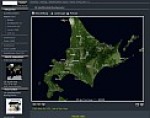
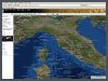
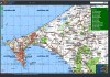
Visit our Demo-Server Atlogis-Maps
and Atlogis-Metamaps
to see 2 examples of web-mapping or try the upper window, where you
can browse satellite imagery of Atlogis and Google Maps.
We offer
• Setup and hosting of GIS-Server farms
• Dynamic Map-Server ( e.g. for Location based Services, Fleetmanagement,
Weathermaps)
• Static Map-Server with Caching-Technology for optimal performance
• Integration of all kinds of spatial data like e.g. vectors, maps,
air photographs, POIs, photos, videos
etc. with meta-data and links
• Database management
• OGC/WMS conformity
• Interface to Google Earth, Google Maps,
WorldWind, and others.
• Interface to GIS-Software like e.g. ArcGIS
• AJAX-, Flash- or JAVA - FrontEnd for user-friendly clients with
high functionality (e.g. Routing, Editing- and Analysis-Tools or database
queries.
• High-Performance and cost-effective Back-End-Solutions like UMN
Mapserver or PostgreSQL/PostGIS
• Layer-Architecture for combination with other Web-Mapping-Services
like e.g. Google, Yahoo or Microsoft Maps or other WMS-Servers.
Google Earth and WorldWind - Export:
Present your geodata in 3D ! 3D-Geobrowser like Google Earth or WorldWind
have the advantages of large user communities, optimal usability and fast
3D performance. We can make your spatial data compatible with Google Earth
/ WorldWind and we can help you to setup geodata-server that can stream
directly to Google Earth / WorldWind clients.
Solutions for Google Earth / WorldWind
• Conversion of vector-data (points, lines,
polygons) • Conversion of raster-data like e.g. topo-maps
or satellite images ( unlimited size !) • Generation of 3D-models with textures • Generation of KMZ-files for your clients • Setup and hosting of GIS-server with interface
for Google Earth / WorldWind for access via Internet / Intranet ( also
for large data amounts) • Solutions for access control / copy protection
to grant security for your data.
Google, Microsoft und Yahoo Maps API:
Für viele Bereiche wie z.B. der Präsentation von Points of Interest
oder eine Anfahrts-Skizze bieten die APIs von Google, MSN und Yahoo Maps
(u.a.) weitreichende Funktionen für eine informationsreiche und benutzerfreundliche
Visualisierung.
Wir helfen Ihnen gerne, die APIs in Ihre Homepage zu integrieren und für
Ihre Zwecke optimal zu nutzen.