Home Contact  
 
Satellite images 15m LANDSAT 7 mosaic 30m LANDSAT 5 mosaic 120 – 1920m Landsat 15m ASTER Satellite image maps
Digital maps Shaded relief maps World-vector-map-set
Products Atlo3D Atlomaps
Services GIS / Remote Sensing Web-GIS 3D Visualization GIS-Server/Data Hosting Large format printing (LFP)
Shop Atlogis Map Shop

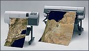
Large format printing (LFP) of satellite images and maps


We print for you on modern large format printers high-quality prints of satellite images, maps and other GIS-data. Prints up to DIN A0 and more are possible, on demand also laminated.


We care for an optimal image preprocessing:

• Digital image enhancement
• Integration of vector data
• Layout with legend and overview map
• Grid (custom projections and datums)
• Integration of custom GPS-Data (tracks, waypoints) or Atlogis vector-data (e.g. citynames)


Please contact us for further information.


Geo-Browser for our satellite imagery and maps.
Mapshop
We provide excellent satellite image mosaics and relief maps from any place on earth including height maps and vector data.

Geo-Browser for our satellite imagery and maps.
Landsat 7 v2 mosaic
Global satellite image in
natural color.

Topographic Maps
Topomapper
Browse world-wide
topographic maps.
» Print » Top » Back