Satellite image maps On Demand (large
format Prints / Posters)
Atlogis satellite image maps are high-quality
large scale prints of natural color satellite images combined
with vector data. Ideal for planning and navigation of travels or expeditions.
Excellent Quality ! Compose your own satellite image map !
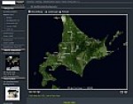
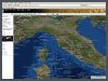
• World-wide coverage, selection via Satellite image poster configurator
• Format sizes: 110x78cm (Poster) or custom formats. • Scales 1: 100.000, 1: 200.000, 1: 400.000,
1: 800.000, ...1: 25.000.000 • High-Quality 190g/m² semigloss Photopaper.
• Printed with UV-resistent (up to 75 years)
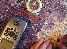
UltraChrome K3 Pigment Ink and 720 DPI ! • Optional WGS84 grid - ideal for GPS-navigation) • Integration of custom GPS-data (e.g. tracks,
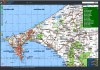
waypoints) is possible • Optional labels and geographic vector features such as
country-, city-, lake-, river- and mountain-names, borders, contour lines,
e.t.c. • Prices start from 49 € incl. VAT
Please visit our Map Shop
for more information and print previews.