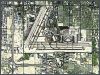
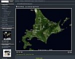
Landsat 7 Satellite Images
simulated Natural Color Global Mosaic
The global satellite image mosaic with a resolution of 14.25
Meter/Pixel was developed by Atlogis and achieves nearly full coverage
of the land masses.
See for yourself the outstandig quality of the mosaic. more»
Landsat 5 Satellite Images simulated
Natural Color Global Mosaic Our Landsat 5 mosaic with 28.5
Meter/Pixel Resolution is a cost-effective alternative
to our Landsat 7 Mosaic. Combined with Landsat 7-images it is possible to
analyse changes in landscape. more»
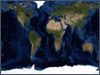
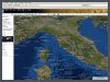
Satellite Images Medium Resolution
We offer global satellite image mosaics also in resolutions of 120|240|480|960
or 1920 Meter / Pixel. These satellite image mosaics are color coordinated
to our Landsat 7-Mosaic and can be combined with it. more»
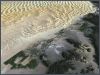
Aster simulated Natural Color Satellite
Images
See Aster satellite images in simulated natural color. Atlogis can bring
the originally false color images to simulated true color with a natural
appearance. more»
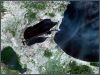
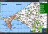
Satellite Image Map
Atlogis Satellite image maps are high-quality digital prints from our Landsat-7-satellite
images. Ideal for planning and navigation of travels or expeditions. more»
Mapshop We provide excellent satellite image mosaics and relief maps from any place on earth including elevation data.