|
GIS and Remote Sensing Services
Atlogis uses state of the art hard- and software
for analysing and processing spatial vector and raster-data. We offer
the complete palette of GIS and remote sensing techniques to make
the best out of your geodata.
GIS-Services
• Geodata processing (analysis, conversion and visualization)
• Setup of geodata-infrastructures for intranet and internet
• Vectorizing and digitizing of raster-data, (semi-) automated
raster-vector conversion (R2V)
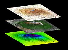
• 3D-modelling / 3D analysis
• AM/FM/GIS technologies
• Cartography for print and digital media
• Location Based Services, GPS based Vehicle Tracking
• Consulting for GIS- hardware and software solutions
Photogrammetry and Remote Sensing:
• Satellite image processing (analysis, conversion and visualization)
• Generation of colorbalanced and seemless satellite image mosaics
• Classification, raster-vector-conversion (R2V)
• Pan-Sharpening
• Georeferencing and orthorectification
• 3D visualization and analysis
• 3D elevation/terrain models
|
|
Please contact
us for further information.
|
|
Mapshop
We provide excellent satellite image mosaics and relief maps from any place on earth including height maps and vector data. |
|
|