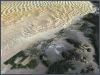
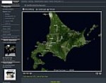
Satellite Images
Atlogis provides ideal satellite imagery for web-mapping, GIS, navigation
and print -
single scenes or complete colorbalanced global mosaics.
more»
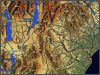
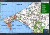
Vector-Maps
We deliver high-quality vectordata for GPS-navi- gation-systems or web-
mapping services. Our products include worldwide vector map sets and high-detailed
regional vector maps with routing functionality. more»
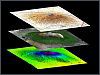
GIS and Remote Sensing Services Atlogis
uses state of the art hard- and software for analysing and processing spatial
vector and raster-data. We offer the complete palette of GIS and remote
sensing techniques to make the best out of your geodata. more»
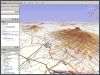
Web-GIS We
help you develop and host customized web-GIS applications for your geodata
- from company-internal intranet-GIS to high-performance Internet web mapping
services. more»
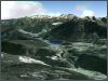
3D-Visualization / Animation
We can use our several terabytes large archive of satellite imagery and
height data to generate high-end 3D-visualizations and animations for any
place in the world. more»
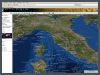
Mapshop
Choose your map area of interest. All satellite and relief images are available with vector map data and can be edited with programs like Illustrator, CorelDraw or Inkscape. Elevation maps ("DEM" or "Bump Map") are available for 3D visualization.
http://mapshop.atlogis.com
Mapshop We provide excellent satellite image mosaics and relief maps from any place on earth including height maps and vector data.