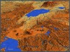
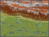
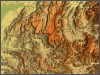
Atlogis offers Shaded
Relief Maps with world-wide coverage. Shaded relief, or hill-shading,
simulates the cast shadow thrown upon a raised relief map. Atlogis
uses the best available sources of digital elevation data to generate
relief maps with resolutions between 30 and 1000 meters. We offer
different color modes and also a special greyscale shaded relief version
that can be used to easily add hill-shading and illumination to conventional
satellite images or topographic maps.
Please visit Atlogis Map Shop and browse our large choice of relief maps.
Use the Relief Map Configurator and choose individual extents,
resolution and type of the map. Optional vector and elevation data can be ordered. Create realistic 3D views with 3D Configurator.
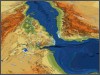
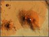
Creation
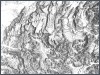
Our shaded relief maps are generated from NASA SRTM data. SRTM data must
be extensively corrected because the orginal data set contains massive
gaps due to e.g. radar shadows caused by rock masses. For the alps and
high asia these gaps were filled with newly generated elevation data from
large scale topographic maps. The result is elevation data that is far
more accurate than the original SRTM data with 90 meters/pixel resolution,
as you can see on this example Mt.
Everest .
Specifications
• Available resolutions: 2000 | 1000 | 500 | 90 und 30 meter/pixel
(30 meter/pixel only for USA)
• world-wide coverage with 90 meter/pixel, north of 60°N and
south of 60°S only 1000 meter/pixel
• Color mode like on our Physical
relief map or on demand ( e.g. greyscale shaded relief for
generation of hill-shading)
• Further options: different sun angle / elevation and exaggeration
• Mosaics can be tiled for faster rendering (e.g. for Web-GIS)